|
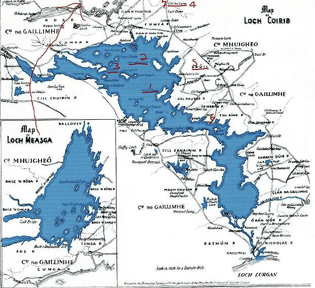
This is a scan of the map which accompanied William R. Wilde's "Loch Coirib - Its Shores and Islands". It is based on the Admiralty Chart made in 1846 and the Ordnance Survey Maps which show the principal islands, the navigation course, the rivers and the chief objects of interest along the shores.
|
| Lough Corrib William Wilde's "Lock Coirib - Its Shores and Islands"was written when Irish was still the language of the people during the second half of the 19th century. In the travelogue mode, it presents a general description of the Corrib's islands and shores, avoiding any social description. |
|
As reference is made to three of the islands in my commentaries, I have typed in their names. They happen to be the three largest islands of Inis Uí Chuinn (Inchaquinn), Inis Mhic a'Trir (Inishmicatreer) and Dubhros (Duros). |
| Wilde's book is available at - www.galway.net/galwayguide/history/wrwilde/ |
| This is what he wrote: Running out from the land in a western direction, and about a mile in length, is the long, low, narrow Island of Inis mhic a' trír, containing a few cottages, the meagre ruins of an ancient church, and also a burial ground.Of this ecclesiastical building we have no account; and there is not a single stone left whereby to judge of its style.It is, however, probable that on this island, as well as on the neighbouring one of Inchiquin, to which it is second in size, may have been erected one of those religious establishments referred to the times of Brendan, Maeldun, and Fursa; for there is great difficulty in determining the precise topography of many of the places in this district mentioned by the hagiologists; and when Colgan wrote he was evidently not personally acquainted with the locality, and his sources of research were chiefly Continental.The shores of this island abound with those peculiar perforated limestones already referred to and at the eastern end they form a causeway, which, with the aid of "a plank," connects it in summer time with the mainland. |
 Clan Coleman
